Engilchek Glacier

The Engilchek Glacier are two large valley glaciers in the Central Asian Tien-Shan. Engilchek Glacier is the biggest glacier in Kyrgyzstan and the southern Engilchek is one of the world's largest glaciers outside the Polar Regions.
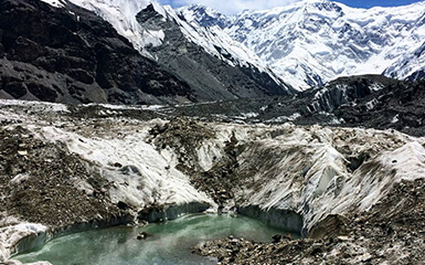
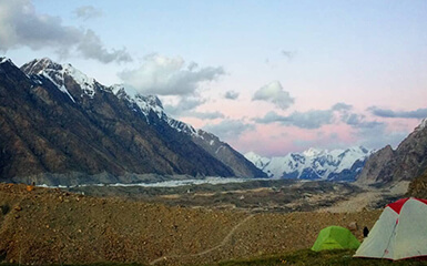
The nearest city is Karakol. From the glacier, you can see many peaks 5000 to 7000 meters high. Camping on the ice can be a big hard for some but there are many camp bases along the way. Make sure to bring very warm clothes and good equipment.
The Engilchek glaciers are located in the border triangle between Kyrgyzstan, Kazakhstan and the Uyghur Autonomous Region Xinjiang in the People's Republic of China. Its borders meet at the summit of the 7,010 m high Khan Tengri, which forms the highest point in the Tengritoo (formerly the Stalin chain) called ridge between the two glaciers. The two Engilchek glaciers at the north and south foot of the Tengritoos flow parallel to it from east to west. Their nutrient areas are sealed off in the east by the meridional chain, the main ridge of the Tienshan, which stretches from north to south.
The meltwater from the Engilchek glacier does not reach the sea. They flow over the Engilchek River of the same name into the Sarydjas, which breaks through the main Tien Shan chain southwards to China. The water flows over Kumarik and Aksu into the Tarim basin. Finally, the Aksu unites with the Yarkant to form the Tarim, which is lost in the Tarim basin named after him, without any drainage, in the vast expanses of the Taklamakan and Lop Nor deserts.
The northern Engilchek lies in the glacier valley between the mountain ridges of the Tengritoos on the south and the Sarydschas chain on the north. It used to be believed to be a tributary of its southern counterpart. In fact, the two branches separated a long time ago - probably in the second half of the 19th century, i.e. at the end of the Little Ice Age. In the course of the general melting of the glaciers, the Northern Engilchek has now retreated far into its upper valley. With a length of 25 kilometres and a width of up to 2 km, it is significantly smaller than the southern Engilchek.
The uppermost basin of the Northern Engilchek is located entirely on Kazakh territory. Coming from Khan Tengri, the state border with Kyrgyzstan runs in a straight line northwest over the glacier to Peak Semjonow, a 5816 m high mountain in the Sarydjas chain.
The southern Engilchek on the north side of Kokshaaltoo and Engilchek is the largest glacier of the Tienshan. Its length is given (in different sources slightly different) at around 60 kilometres. The information on its area also fluctuates significantly; among other things, 488 km² and 567 km² are published. Values over 800 km² should relate to the total area of both glaciers.