Kok Gumbaz
Ajina Teppa
Ancient Panjakent
Anzob Tunnel
Beshkent Qala
Childukhtaron
Khazrati Shokh
Mug Teppa
Gharm Chashma
Hisor Historical
Haji Yaqub mosque
Hazrati-Bobo complex
Lake Iskanderkul
Kalai-Khumb
Karatag
Karon
Khishtin caravanserai
Khorog
Khulbuk
Lake Karakul
Abdullatif Sultan
Madrasai Kuhna
Abu Abdullah Rudaki
Khoja Mashhad
Khudoyor Valami
Makhmudi Azam
Mir Sayyid Ali Hamadani
Muhammed Bashoro
Sheikh Muslihiddin
Nurek Mountain Lake
Pamir
Sarazm
Sari-Khosor
Seven Lakes
Shirkent
Chiluchorchashma
Takht-i Sangin
Shirkent National Park

Shirkent National Park is 100 km west of Dushanbe. The Karatag River flows through the park on the southern slopes of the Gissar mountain range.
The national park "Shirkent" is well known because of the footprints of petrified dinosaurs from the Upper Jurassic and Lower Cretaceous deposits. Three rare dinosaur footprint sites from various eras have been discovered in the Shirkent Valley, containing more than 400 trails. The first location of this giant, ancient reptile is located on one of the right banks of the Shirkent River, slightly above a village of the same name. Two rows of pterodactyl footprints are seen on the surface of the Erinali limestone. Footprints average 0.5 m in length, up to 30 cm in width, and about 75 cm in stride length. Since no known footprints were found elsewhere, as at Shirkent, the animal that left them was placed in a new dinosaur species, a suborder of Theropoda, and named Macropodosaurs Gravis. The footprints of the second group of dinosaurs are located about 5 km from the mouth of the river Shirkent, near the watershed on its left side. The third group of footprints is located near the village of Pashmi Kuna and only has the footprints of Tridactylous, but it was a real giant. Its feet are 70 cm long, 60 cm wide, and the depth of the ground depression under the footprints is up to 10 cm. However, dinosaur footprints are not the only attraction here.
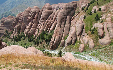
Not everyone can look ahead and reveal the secret of the mysterious "Shirkent barrier", because the Shirkent riverbed in the middle stream is compressed by an almost impassable canyon that protects the original reserve land world.
Remnant juniper trees have replaced noble plane trees. Vast high alpine meadows, an abundance of rivers and streams provide shelter for the reserve's rich wildlife.
The panorama of Upper Shirkent impresses with its splendor and splendor of landforms. Surrounded on all sides by high and rugged mountains, the valley ends in the north with the Koldyrga snow range, which specific peaks reach 4400-4500m.
Against the background of grey granite rocks and sparkling snowfields, the lower relief layer of red-coloured sandstone and conglomerate is clearly visible here, forming a wide step that stretches for more than five kilometres and is called the “Shirkent Barrier”. The bizarre shapes eroded and sharpened by the water giant “towers” and “castles” of reddish rock are followed by beautiful juniper-covered terraces that give the fairy-tale castle the entire Shirkent barrier look. It has created mountain streams, natural baths, waterfalls, and caves that once flowed its way for centuries in a single monolith of reddish rocks. Visiting the Shirkent barrier will leave a lasting impression on you.

