Ashgabat
Alem Ferris wheel
State Museum
Fine Arts museum
Wedding Palace
Nisa fortress
Memorial Complex
Ertogrul Gazi Mosque
Neutrality monument
Independence Park
Turkmenbashi Ruhy Mosque
Olympic Village
Ylham Alley
Carpet Museum
Monument of Lenin
Ahal Region
Abivert
Altyn Depe
Annau
Darvaza
Geokdepe
Kowata
Mane baba
Zengi baba
Nedir Shah
Nokhur
Parzdepe
Sarahs baba
Seyit Jemaleddin mosque
Shahrislam
Ulug depe
Mary region
40 cupolas
Akcha Kala
Ancient Merv
Badkhyz
Chilburj
Gebeklytepe
Geok Gumbaz
Gurtly Depe
Kharoba Koshuk
Talkhatan Baba
Yekedeshik
Dashoguz region
Ashyk Aydyn Pir
Devkeshen
Ismamit ata
Kalaly-gyr
Kaplankyr Nature Reserve
Kunya-Urgench
Damla
Balkan region
Dehistan
Yangikala
Awaza
Gozli ata
Kemal ata
Mashat ata
Paraw bibi
Lunar Mountains
Shevlan Baba
Igdy kala
In 1987, the Ministry of Culture of Turkmenistan decided to establish the Ancient Merv State Historical and Cultural Reserve to protect the walled cities of Ancient Merv and the main monuments in the oasis. Today, the Reserve is an organization that monitors state archeological and historical monuments throughout Mary Province. The reserve's offices are located near the ancient city of Merv (near the mausoleum of Sultan Sanjar), near the town of Bayramali.
The Murgap oasis, which includes Merv and its environs, is one of the earliest settlements in Turkmenistan. Bronze Age settlements here are among the earliest evidence of civilization in Central Asia. In later times, Merv served as the capital of a vast empire and was one of the largest cities in the world during the Seljuk period. Archaeological sites known as Ancient Merv, located near the city of Bayramali, provide evidence of more advanced cities dating back nearly 2,500 years. Merv is also important because it is an important crossroads along one of the main routes of the ancient Silk Road, which crosses half of the world from the Far East to Europe and Africa. Archaeologically, Merv is considered one of the largest and most valuable monuments in the world.
In the 6th century BC, the Achaemenid Empire promoted the development of trade over long distances. The prosperous administrative and commercial centre, now known as Erk Gala, originated in the Murgab Delta. These places were annexed to the Hellenistic (Greek) world by the end of the 4th century B.C. The eastern part of his empire soon became part of the Seleucid Empire, and during the reign of Antiochus I (b.281-261) Erk Gala became the citadel of the great, newly walled city, Antioch Margiana (now called Gavur Gala).
With the rise and fall of empires and trade, the city of the Great Gavur Gala continued to grow over the next 1,000 years. The Parthians (c. 250 BC), and later the Sassanids (c. 226 BC), developed Merv as an important administrative, military, and commercial center. In the 740s, the commander-in-chief Abu Muslim ordered the construction of a mosque along the Majan Canal, which flows one kilometre west of the wall of Gawur Gala. In the 11th century, the mosque of Abu Muslim remained in the center of the thriving city of Marw al-Shahijan (Great Merv: present-day Sultan Gala).
The expansion and development of the Sultan Gala continued throughout the Seljuk period (XI - early XIII centuries); Merv was one of the largest cities in the world during this period. In the 12th century, a walled citadel (Shahriyar Ark), containing a palace complex, administrative buildings and high-quality housing, was built in the northeast corner of the city. In 1221, the Mongol troops came to the gates of Merv. According to historical records, the townspeople were massacred; the city was burned to ashes, and abandoned. In the early 15th century, the newly walled city of Timurid was built to the east of the former cities, and was later renamed Abdullah Khan Gala. Bayramali Khan Fortress, which later served as a township, joined in the 18th century.
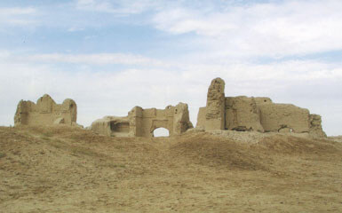
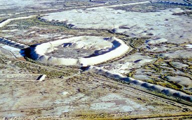
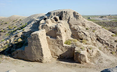
Erk Gala (Persian "The Citadel Fort") is the oldest part of the city of Merv complex. Built in the 7th century BC it was built as a Persian style fortress controlling the oasis on the Murghab River.
In the 6th century BC, the Achaemenid Empire promoted the development of trade over long distances. The prosperous administrative and commercial centre, now known as Erk Gala, originated in the Murgab Delta. These places were annexed to the Hellenistic (Greek) world by the end of the 4th century B.C. The eastern part of his empire soon became part of the Seleucid Empire, and during the reign of Antiochus I, Erk Gala became the citadel of the great, newly walled city, Antioch Margiana (now called Gyaur Gala).
Although Erk Gala is the smallest of the fortresses included in the system of the ancient city of Merv, it is the largest in age and the highest in height. It covers an area of only 20 hectares. Nowadays, it looks like a mountain that is difficult to climb, not a fortress. Its retained height reaches an average of 25-28 meters. Numerous archaeological excavations have revealed that the fortress was the palace of the Achaemenid-era ruler. In addition to the palace, Erk Gala had a large office building, warehouses, a barn, and barracks for servants.
It is located in the middle reaches of the Murgab River in Turkmenistan, near the town of Bayramali. Erk Gala is the oldest part of Merv. The history of Erk Gala is oval (400 × 500 m - 20 ha), and the defensive walls of Gyaur Fortress attached to the wing. Erk Gala in the centre of the castle/point. There are more than 25 m of arches (50 × 50 m). To the north of the arch is a low platform with a military garrison and stone weapons. A member of the Russian Archaeological Commission, V.A. Conducted by Zhukovsky, carried out the first excavations at Erk Gala in 1890.
The American expedition led by R. Pampelli in 1904, B.B. Piotrovsky, A.A. Marushchenko in 1937 and S.A. Vyazigin in 1947, and the Southern Turkmenistan Archaeological Complex Expedition in 1950-1992 under the leadership of M.Ye. Masson. It was built in the 2nd quarter. During the Sassanid period (3rd-5th centuries), an administrative building was erected on the central hill, which was later used by the Arabs as the residence of Caliph Ma'mun in Merv. According to written sources, Erk Gala has been in ruins since the 10th century. Numerous pottery and glass vessels, Sassanid coins, brass knives, stones, and brass peacocks were found in Erk Gala.
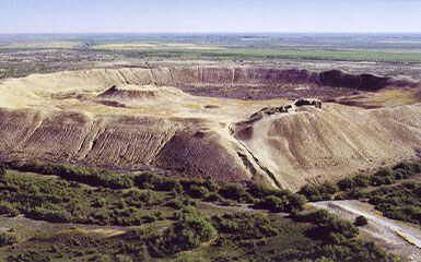
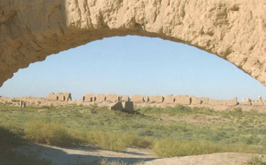
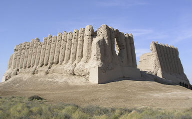
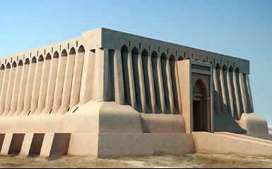
The Gyaur Gala is the fortress in the site of Ancient Merv. The Seleucid ruler Antiochus Soter (reigned 281–261 BC) renamed it to Antiochia Margiana; he rebuilt and expanded the city at the site presently known as Gyaur Gala (Gäwürgala) fortress. The walls of this quadruple fortress, built very quickly, were 6.6 meters thick and 7.4 meters high, with each side wing reaching almost 1.5 kilometres in length. Known in the past as the “Fortress of the Idolaters” or the “Infidelity”. It covers an area of about 360 hectares. After the fall of the Seleucid dynasty (63 BC), Bactria, Parthia, and the Kushans took control in succession. With the rise and fall of empires and trade, the city of the Great Gyaur Gala continued to grow over the next 1,000 years. The Parthians (c. 250 BC), and later the Sassanid (c. 226 BC), developed Merv as an important administrative, military, and commercial centre.
Generals who had fought with Alexander the Great, but were now fighting amongst themselves for his Empire after his death headed the Seleucids. The Seleucids were defeated by the Parthian Empire, which ruled between 247 BC to 224 AD. The ancient city of Nisa, which is located in Ashgabat, was their capital city. It is thought that the Parthians brought the ancient religion of Zoroastrian to Merv, but at the ancient site of Gonur Depe, which is 60 km from Merv, evidence of fire temples were found that are said to date from 1500 BC. The Sasanian Empire defeated the Parthians in 224 and ruled Merv until 651, when the Arabs defeated them. The site of Merv was home to different religions including Christianity and Buddhism. This is actually the furthest site to the West where Buddhism was popular.
After the Arab invasion, the city was destroyed and the building material moved west to build the new city of the Sultan or "Sultan Kala". The mosque here was said to have been built in the 7th century, and the remains of the old site of Gyaur Kala, were built upon as an area for industry. The Mary museum has pottery remains found at the Gyaur Kala site, and most importantly coins of the Sassanid Empire, which were produced at Merv.
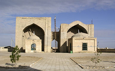
One of the most important pilgrimage sites in Turkmenistan are the mausolea of two Islamic askhabs (companions of the Prophet), Al-Hakim ibn Amr al-Jafari and Buraida ibn al-Huseib al-Islami. The two small buildings sit in front of reconstructed Timurid aivans (iwans, portals) that honour the tombs of the two askhabs.
The Askhab Mausolea is located in the south of Sultan Kala. It is the oldest structure in Sultan Kala, as the tombs were constructed in the 7th century. The complex includes a sardoba, reception building and the tomb area. The reception building is for pilgrims to rest and have a meal. The Arab invaders conquered Merv from the Sassanid in 651.
In 1418, Shakhruh, the son of Amur Timur, began the restoration of the ancient city of Merv, which had been destroyed by the Mongols almost 200 years before. The Askhab Complex was one of the restoration projects undertaken, as the tombs were repaired and aivans were built behind each. The aivans were beautifully decorated with glazed tiles in turquoise and blue colours. Unfortunately, by the end of the 19th century both aivans and tombs had again fallen into disrepair.
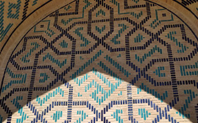
The complex though heavily restored today, is in great condition. The conservators paid particular attention to preserving the remaining tile work, which takes the form of intersecting geometric patterns that frame various square Kufic inscriptions such as the word "Allah" at the centre of a rub el hizb (eight-sided Islamic star). Three colours predominate: a dark cobalt blue, a lighter turquoise, and the backdrop of tan-coloured baked brick. The conservationists were able to match the colour of the original tiles precisely, such that it is difficult to tell old and new tiles apart without close inspection.
The aivans stand tall at 12 meters in height, and many of the original tiles from the Timurid era remain. The Aivans are connected by an archway, which offers a view of the old city walls of Sultan Kala. The aivan to the right had been completely restored with new tilework, but the aivan to the left was still in the process of being restored, with quite a bit of the original tiles still in place. We thought it was a good opportunity to compare the modern and ancient tiles.
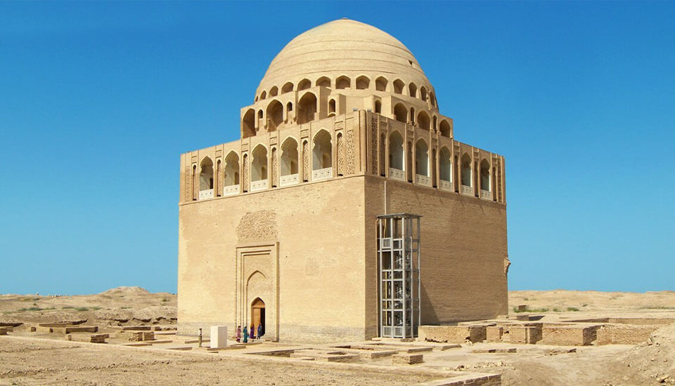
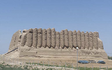
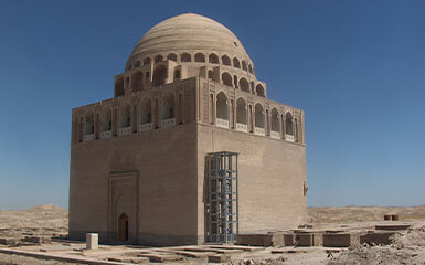
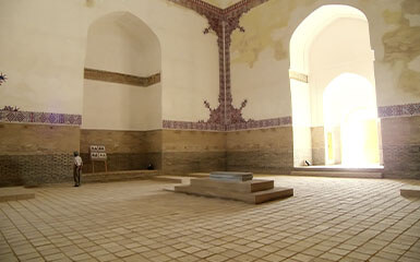
It was built in the middle of the twelfth century by Muhammad ibn Atsyz as-Sarahsi. Art critic G.A. Pugachenkova wrote of the monument: "Even if Merv had disappeared along with the historical information about it and the cities, only this monument alone would have been enough to testify to her former glory."
The mausoleum has a square base with a side length of 27 meters. On the two-story substructure was a 17-meter-high dome, which was covered with turquoise bricks. The dome, the outer shell of which has been destroyed over the centuries, is considered the first double-shell dome in Central Asia. The building rests on a six-meter-deep foundation that made the building earthquake-proof. The massive walls are more than three meters thick. The building has two entrances, a main entrance in the east and another in the west, from where the gallery around the dome can be reached. In the middle of the dome was the eight-pointed Seljuk star and a small opening to the outside, which is the subject of a legend. Inside the mausoleum, there is a cenotaph, which is reminiscent of Sultan Sanjar. His body was taken to an undisclosed location before the Mongol invasion.
Sultan Ahmad Sanjar was the last Sultan of the Seljuq Empire from 1118 to 1157, whose long and successful reign only postponed the fall of the Seljuq Empire. Originally, the mausoleum was not isolated, but was part of a larger building complex with religious significance, which also included a mosque.
In 1937, excavations were carried out around the mausoleum. During excavations in 1996, the remains of a bazaar and a caravanserai were uncovered near the mausoleum. In 1994 extensive restoration, work began on the mausoleum, which was made accessible again after ten years of work by Turkish and Turkmen experts.
The mausoleum is the subject of a legend: Sultan Sanjar fell in love with a peri who, under three conditions, was ready to become his wife. The sultan should not watch her while she combs her hair, never see her feet while she walks and never hug her through her waist. When he could not control himself anymore and finally hugged his wife, he noticed that she had no bones. Confused about the breach of his promise, the peri left the sultan and merely offered him to build a castle for her with a hole in the dome if he wants to see her, where she would go every Friday. The Sultan did this and saw his wife this way weekly until the Sultan died. Out of love, he had ordered himself to be buried in that castle so that it became his mausoleum.
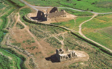
The Great Kyz Kala is a former fortress (7th – 8th century) at the archaeological site of Merv or Antioch in Margiana, Turkmenistan. Merv used to be on the Silk Road.
The entire Merv site is a UNESCO World Heritage Site regardless of the construction period. The Great Kyz Kala is the largest of five fortresses surrounding the Sultan Kala fortress, part of Merv. Kala means fortress and to distinguish it from Sultan Kala, archaeologists sometimes refer to Kyz Kala as a keoshk or fortified house.
The fortress is built of mud. During the Persian rule of the Sassanids, Great Kyz Kala was built, more precisely in the 7th – 8th century. Even after the Persian rule, Arabs carried out, further construction until the 12th century. It is possible that Great Kyz Kala was the home of the Persian governor of Merv. In 1221 the Mongols conquered Merv and construction stopped.
The lower part is a large platform of two meters high and in the shape of a rectangle of 46 x 36 meters. On the platform are walls ten meters high, a total height of twelve meters. The walls enclosed rooms on the first and second floors. The first floor contained sixteen large rooms around a courtyard; the second floor probably eighteen rooms. The stack houses were on the first floor, the second floor was the residence of an important family.
Due to the construction with thick walls, it must be cool inside the house at hot temperatures outside. Each rib in the wall protrudes in the shape of a half octagon. The rib projects sharply outwards and ends at the top with an acute angle as well. There used to be wooden platforms on the roof. The wooden platforms have disappeared but had a role in the defense of the house.
The entrance gate was on the east side. Erosion and destruction make it easier now, to walk in through a hole in the north side. Unlike Great Kyz-kala, Lesser Kyz-kala has been preserved much worse, only the walls remain of it. Thanks to the excavations, it can be judged that the two fortresses were built according to the same plan. During the construction of the arches, burnt bricks were used, and all other buildings were built with the help of adobe and adobe bricks, which the Khorezm architects loved to use in their construction. Inside the fortress, there were residential and utility rooms that formed a courtyard. For the steppe, it was an extremely convenient structure: it was always cool here in summer and warm in winter. This structure was also used as a barn where crops were stored, so it is not surprising that the fortress could withstand a long siege. The two parts of the Kyz-Kala fortress were connected to each other with the help of the eastern gate, on which towers were erected, which had a guard function.
During the Seljuk rule in the 10th century, Merv became one of the largest cities in the world and the capital of an empire that stretched from the Mediterranean to the Amu Darya (Ox River). The Seljuk rulers took Merv in 1037 and by 1040; it had become the capital of the Seljuk Empire. The Seljuks continued to expand the city.
The Shahryar Ark fortress in the north-eastern part of the Sultan Gala was built at the turn of the XI-XII centuries to protect the lands of the rulers. The expansion and development of the Sultan Gala continued throughout the Seljuk period (XI - early XIII centuries); Merv was one of the largest cities in the world during this period. In the 12th century, a walled citadel (Shahriyar Ark) containing the palace complex, administrative buildings and high-quality housing was built in the north-eastern corner of the city. This is also evidenced by the presence of more than 70 defensive towers on the wall of the fortress, which covers an area of about 20 hectares. The area consists of a palace complex, administrative buildings and good houses and gardens for the most important residents. Judging from the modern parts of the fortress, it can be seen that its Seljuk palace was built on the basis of outstanding examples of medieval architectural art.
Shahriyar Fortress is the smallest of the ancient fortresses of Mary. The certain way has not been followed in the construction of the walls of this fortress. The fortress looks like irregular square. It is mainly made of 27 × 27 × 6 cm size bricks. Currently, the remained thickness of the fortress walls is 2.8-3 meters and the height is 8-10 meters. In the northern and north-western parts of the citadel can be seen the remains of barracks, stables, and in the middle and southeast, the ruins of offices and dwellings. The most attractive of them is the palace. Inside the palace was the only stretching hall, which at one time served as the divan-reception of the Seljuk sultans. The most interesting building to see here is the Kepderhana. This may have been a small palace that served as a library or administrative structure. There are remains of a house that may have been the palace of Sultan Sanjar in the vicinity.