Ashgabat
Alem Ferris wheel
State Museum
Fine Arts museum
Wedding Palace
Nisa fortress
Memorial Complex
Ertogrul Gazi Mosque
Neutrality monument
Independence Park
Turkmenbashi Ruhy Mosque
Olympic Village
Ylham Alley
Carpet Museum
Monument of Lenin
Ahal Region
Abivert
Altyn Depe
Annau
Darvaza
Geokdepe
Kowata
Mane baba
Zengi baba
Nedir Shah
Nokhur
Parzdepe
Sarahs baba
Seyit Jemaleddin mosque
Shahrislam
Ulug depe
Mary region
40 cupolas
Akcha Kala
Ancient Merv
Badkhyz
Chilburj
Gebeklytepe
Geok Gumbaz
Gurtly Depe
Kharoba Koshuk
Talkhatan Baba
Yekedeshik
Dashoguz region
Ashyk Aydyn Pir
Devkeshen
Ismamit ata
Kalaly-gyr
Kaplankyr Nature Reserve
Kunya-Urgench
Damla
Balkan region
Dehistan
Yangikala
Awaza
Gozli ata
Kemal ata
Mashat ata
Paraw bibi
Lunar Mountains
Shevlan Baba
Igdy kala
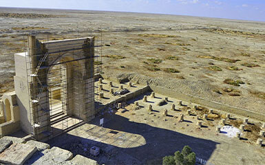
Turkmenistan has its intriguing history and Dehistan is one of the most ancient cities in Turkmen land. The city was the abode of the Ancient IronAge. Dehistan- an area that includes the lower reaches of the Etrek River of Balkan province, 22 kilometers northwest of the village of Madaw. The city name derived from inhabitants of Dah tribes which means “the country of villages”. According to other sources, the name came from the Parthian kingdom rulers, Arshakids-Dahs who were the descendants of the ancient nation Sak-Massaget tribes. The city witnessed the Seljuk dynasty, the Great Khorezm, Alexander the Great, Greek-Roman rivalry for the dominance in the East, and Mongol invasion.
The Dehistan reached its peak during the Khorezmshahs. Then it flourished under Parthians by Alexander the great and his successors. It was on the trade route during 10-14th centuries. And it was also mentioned as Al-makdisi in arab geographic books. It was referred to the city of Rabat as the center of Dehistan, which means a city-fortress. It is possible to learn from the statues of Abu Bakr al-Sul, the king of Dehistan, who built the capital of the Arab Caliphate in Baghdad in the 10th century. Moreover, Dehistan bears witness to the past splendor of the oasis of Mistriane, where the first traces of urbanization date back to the third millennium. Archaeologists consider that the region has undergone three phases of development: The third Millennium before our era until the first century. The oasis was populated by farmers who controlled irrigation techniques. Between the third and the eighth century, Mistriane is occupied by tribes of Turkish origin, which are primarily semi-nomadic breeders. A few mounts scattered in the dates plain of that time. But the main archaeological remains date from the third stages of development in the region. The city covered an area of 200 ha and included a citadel surrounded by residential quarters. The citadel was protected by two rows of rough watchtower ramparts. These protections did not allow the Shahs of Khorezm who lived there to resist the Mongolian armies, which largely ravaged the city in the 13th century. Mistriane, however, managed to recover after the Passage, but only to turn off above a century later, hit by an enemy much more unforgiving than the Mongols: desertification.


From this past splendor, few remains are still standing. Part of the ramparts has nevertheless been preserved. Two minarets of the 13th century are still in good condition, and the ruins of mosque doors always stand in the middle of the desert. And one of them still has beautiful blue ceramic inscriptions in its upper part. The foundations of four mosques from the Mongol period were updated on the site. At 7 km from there lies the cemetery of Meshked, where you can still see five tombs. The best-preserved is Shir-Kabir, which is both a mausoleum and a small mosque. It is a place of fairly frequented pilgrimage, as evidenced by the hundreds of votive tissues hanging inside the mosque. The cemetery floor is dotted with small stone pyramids. These represent the prayers of pilgrims who come to ask for the protection of spirits.
